Case study · draft
A student project from the Rethinking.Logistics studio showing how tools deliver metrics for decisions.
| Student | Khrystyna Verbitska |
| Project | Urban Logistic Hub |
| Portfolio | heyzine.com/flip-book/c97c8fb64f.html |
| Studio | AD4 |
| Year | 2026 |
| Location | Prague 11 – Háje, Prague (former industrial / abandoned building next to a housing estate) |
| Typology | urban last-mile micro-hub (cargo-bike and EV dispatch) with showroom and community roof garden, adaptive reuse |
| Status | draft |
Project
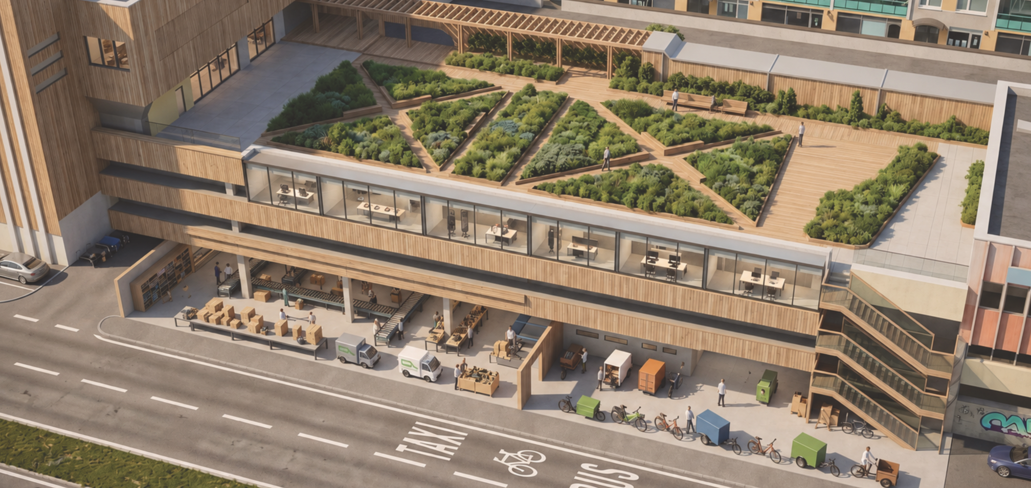
The project starts from the shortage of last-mile micro-hubs in Prague (only Florenc and Smíchov identified) and the traffic, emission and kerbside problems caused by deliveries coming from warehouses outside the city. Using a city-wide map of brownfields and abandoned buildings, it selects an abandoned concrete structure in Háje and converts it into a micro-hub that sorts parcels and dispatches them by cargo bikes and electric vehicles. The building is stacked by floor: a ground-level logistics layer for loading, sorting and bike/EV servicing, a showroom and repair/community level above, and a public rooftop garden. Two spatial proposals were explored: a hybrid model where logistics and public programmes overlap, and a floor-separated model to avoid operational conflicts.
How the student framed the challenge
- Urban integration of logistics buildings
- Last-mile delivery emissions and traffic
- Adaptive reuse of abandoned urban buildings
- Public access and community use of logistics sites
Metrics and evidence
Every metric the project used, as named by the student, with the value, the calculation and the portfolio page.
| Metric | Student’s wording | Value | How it was calculated | Tool | Page |
|---|---|---|---|---|---|
| Green area ratio | +35% Green Surface Area | Existing: mostly sealed industrial surfaces; proposal: approx. 210 m² of new green surface on a 600 m² site, approx. +35% vegetated area | New vegetated surface (roof garden and planted areas) divided by site area. | manual / formula | 14-15 |
| Embodied carbon saved by reuse | Carbon Reduction | 600 m² × 500 kgCO2e/m² = 300,000 kgCO2e for new build; approx. 210,000 kgCO2e saved by reuse | Building area × benchmark embodied carbon of new construction (500 kgCO2e/m²) × assumed saving share of reuse (70%). | manual / formula | 16-17 |
| Publicly accessible area | +210 m² of Accessible Community Space | Existing: 0 m²; proposal: approx. 210 m² (rooftop public garden ~150 m² + showroom and interaction zone ~60 m²) | Sum of floor areas open to the public (rooftop garden plus showroom/interaction zone), compared with the existing state. | manual / formula | 18-19 |
| Delivery time | End-to-end cycle time | 64% faster | Relative reduction of delivery cycle time when a micro-hub is added to the supply chain; source of the figure not stated (appears to be a literature value for the micro-hub model, not computed for this site). | not stated | 6 |
| Last-mile delivery cost | Supply chain cost | 34% lower | Relative reduction of transport and handling costs in the micro-hub model; source of the figure not stated. | not stated | 6 |
| Last-mile delivery emissions | CO₂ emissions | 40% reduction | Relative reduction of delivery emissions from localized distribution and clean mobility (cargo bikes, EVs); source of the figure not stated. | not stated | 6 |
Tools
No digital tool is named in the portfolio — values were estimated by hand, taken from literature, or not quantified.
Trade-offs
- Prioritising cargo-bike deliveries lowers CO2 emissions and urban traffic impact but reduces throughput and scalability, especially at peak demand (emissions vs. logistics capacity).
- Mixing public programmes with logistics increases community space and social integration but creates operational conflicts, congestion and noise at peak dispatch times (public accessibility vs. operational efficiency); addressed by comparing a hybrid layout with a floor-separated layout.
Decision
Reuse an abandoned building on an inner-city brownfield instead of building new, which supports the embodied carbon saving and the green and public space gains. The floor-separated scheme (logistics at ground level, showroom/community above, public roof garden on top) is the one developed in the exploded axonometric.
Open questions
- Integration into the city and the connection between neighbours and the chosen location was identified as a gap at mid-term (questionnaire 1.3).
- Research depth and testing of alternatives named as the biggest gaps (questionnaire 6.2).
- Electricity price and grey-water strategy not answered in the questionnaire.
- Walkability, accessibility and adaptability are named as KPIs in the questionnaire but are not quantified in the portfolio.
Connections
- Challenges addressed: Urban integration of logistics buildings, Last-mile delivery emissions and traffic, Embodied carbon and adaptive reuse of logistics buildings, Public access and community use of logistics sites
- Metrics used: Green area ratio, Embodied carbon saved by reuse, Publicly accessible area, Delivery time, Last-mile delivery cost, Last-mile delivery emissions
Something wrong or missing? Suggest a correction